Flow direction and DEM conditioning#
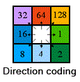
The model routes water by using a flow direction raster, which uses standard eight-direction (D8) flow direction enconding. In nfdata, this flow direction can either be provided by the flow_dir parameter, or nfdata can attempt to deduce it from a digital elevation model (DEM) provided by the dem parameter.
flow_dir or dem as a basis for the grid
Either the flow_dir, or if flow_dir isn’t present, the dem variable, is used as the basis for the grid that defines the NetCDF file output by nfdata. That is, parameters such as the CRS, bounds, resolution and mask are obtained from this variable. nfdata does not do any reprojection of rasters from other grid systems (therefore, all provided rasters should be the same CRS and resolution), but it does clip rasters to the extent of flow_dir/dem. This clipping includes masking over nodata values in flow_dir/dem, and therefore it is one of these variable that decides which grid cells are modelled.
Directly providing flow_dir#
If the flow_dir variable is present in nfdata’s config, this will be used as the flow direction (regardless of whether dem is present). This variable should be a raster (openable by Rasterio) and have an integer data type with either D8 values or nodata values.
This flow direction must be resolved, otherwise running the model with it will fail. By resolved, we mean that all non-masked (nodata) cells must have a non-zero D8 value (1, 2, 4, 8, 16, 32, 64, 128), and that these values must not result in “pools” where cells flow into each other (e.g. neighbouring cells with the northerly cell having flow_dir=4 and a southerly cell having flow_dir=64).
The flow_dir group in the config file must contain a path, and optionally a crs value. The CRS is usually deduced from the provided raster, but in the case of rasters with ill-defined CRSs, the crs option gives the ability to override this. Note that this does not reproject the raster to this CRS, it simply assigns the CRS to the raster.
Calculating flow_dir from a DEM#
Alternatively, if the dem variable is present and flow_dir is not, the model will attempt to deduce the flow direction from this DEM. To achieve this, either a conditioned DEM should be provided, or the config option condition_dem must be present to instruct nfdata to attempt to condition the DEM.
By conditioned, we mean that no pits, depressions or flats should be present in the DEM, as these will prevent a fully-resolved flow direction from being calculated. If an unconditioned DEM is provided (and the condition_dem option is not specified), nfdata will raise an error. There are numerous tools available that can help condition DEMs.
If condition_dem is present, nfdata will attempt to condition the DEM using Whitebox Tools’ breach_depressions_least_cost routine. This is a fairly robust tool that is usually able to resolve most DEMs without significant alterations, but it might not work in all cases. condition_dem can either be True, or be a dict of further config options:
condition_dem:
  # If `save_dem_to_path` is set, the conditioned DEM will be saved to this path
  # (even if the conditioning hasn't fully worked). If not, a temporary directory
  # is used and the resulting DEM is deleted after the processing.
  save_dem_to_path: ./dem.tif
  # Additional config options specified here will be passed to `breach_depressions_least_cost`
  # See https://www.whiteboxgeo.com/manual/wbt_book/available_tools/hydrological_analysis.html#BreachDepressionsLeastCost
  # If a value for `callback` is provided, it is ignored as we implement our own callback to
  # deal with errors. The only required (by Whitebox) parameter is `dist`, which specifies
  # the maximum search distance for breach paths in cells. The default value used in nfdata is 10000.
  dist: 10000
Important
Currently, nfdata’s flow direction algorithm assumes that nodata (masked) cells and cells immediately outside of the DEM’s bounding box are at a very low elevation, therefore forcing the flow direction from neighbouring cells towards them. Effectively, this means that nodata cells and the region outside of the DEM are treated as waterbodies into which neighbouring cell drain. Therefore, we only recommend to use this flow direction calculation functionality if this is a valid assumption for your scenario, otherwise you should provide a pre-resolved flow direction raster.