Section 13 CORINE Land Use
13.1 Background
The CORINE Land Cover product (“CORINE Land Cover — Copernicus Land Monitoring Service” n.d.) consists of an inventory of land cover in 44 classes. CORINE is produced within the framework of the Initial Operations of the Copernicus programme (the European Earth monitoring programme previously known as GMES) on land monitoring. It attempts to provide consistent information on land cover and land cover changes across Europe. CORINE is produced by semi-automatic interpretation of high resolution satellite imagery, following a standard methodology and nomenclature with the following base parameters: - 44 classes in the hierarchical three level Corine nomenclature; - Minimum mapping unit (MMU) for status layers is 25 hectares; - Minimum width of linear elements is 100 metres.
Maps were available for 2000, 2006, 2012, and 2018 as a 100-m raster product (version updated 2020). Processing involved the reprojecting from Lambert Equal Area projection to OSGB36 coordinates, and re-classifying the 44-classes to the six LULUCF classes. The table below shows the correspondence between CORINE classes and LULUCF classes.
| CLC_CODE | Corine_name | LULUCF_ID | LULUCF_name |
|---|---|---|---|
| 1 | Continuous urban fabric | 5 | urban |
| 2 | Discontinuous urban fabric | 5 | urban |
| 3 | Industrial or commercial units | 5 | urban |
| 4 | Road and rail networks and associated land | 5 | urban |
| 5 | Port areas | 5 | urban |
| 6 | Airports | 5 | urban |
| 7 | Mineral extraction sites | 5 | urban |
| 8 | Dump sites | 5 | urban |
| 9 | Construction sites | 5 | urban |
| 10 | Green urban areas | 3 | grass |
| 11 | Sport and leisure facilities | 3 | grass |
| 12 | Non-irrigated arable land | 2 | crop |
| 13 | Permanently irrigated land | 2 | crop |
| 14 | Rice fields | 2 | crop |
| 15 | Vineyards | 2 | crop |
| 16 | Fruit trees and berry plantations | 2 | crop |
| 17 | Olive groves | 2 | crop |
| 18 | Pastures | 3 | grass |
| 19 | Annual crops associated with permanent crops | 2 | crop |
| 20 | Complex cultivation patterns | 2 | crop |
| 21 | Land principally occupied by agriculture with significant areas of natural vegetation | 3 | grass |
| 22 | Agro-woodsry areas | 1 | woods |
| 23 | Broad-leaved woods | 1 | woods |
| 24 | Coniferous woods | 1 | woods |
| 25 | Mixed woods | 1 | woods |
| 26 | Natural grasslands | 4 | rough |
| 27 | Moors and heathland | 4 | rough |
| 28 | Sclerophyllous vegetation | 4 | rough |
| 29 | Transitional woodland-shrub | 4 | rough |
| 30 | Beaches dunes sands | 6 | other |
| 31 | Bare rocks | 6 | other |
| 32 | Sparsely vegetated areas | 6 | other |
| 33 | Burnt areas | 6 | other |
| 34 | Glaciers and perpetual snow | 6 | other |
| 35 | Inland marshes | 4 | rough |
| 36 | Peat bogs | 4 | rough |
| 37 | Salt marshes | 4 | rough |
| 38 | Salines | 6 | other |
| 39 | Intertidal flats | 0 | NA |
| 40 | Water courses | 0 | NA |
| 41 | Water bodies | 0 | NA |
| 42 | Coastal lagoons | 0 | NA |
| 43 | Estuaries | 0 | NA |
| 44 | Sea and ocean | 0 | NA |
| 45 | NODATA | 0 | NA |
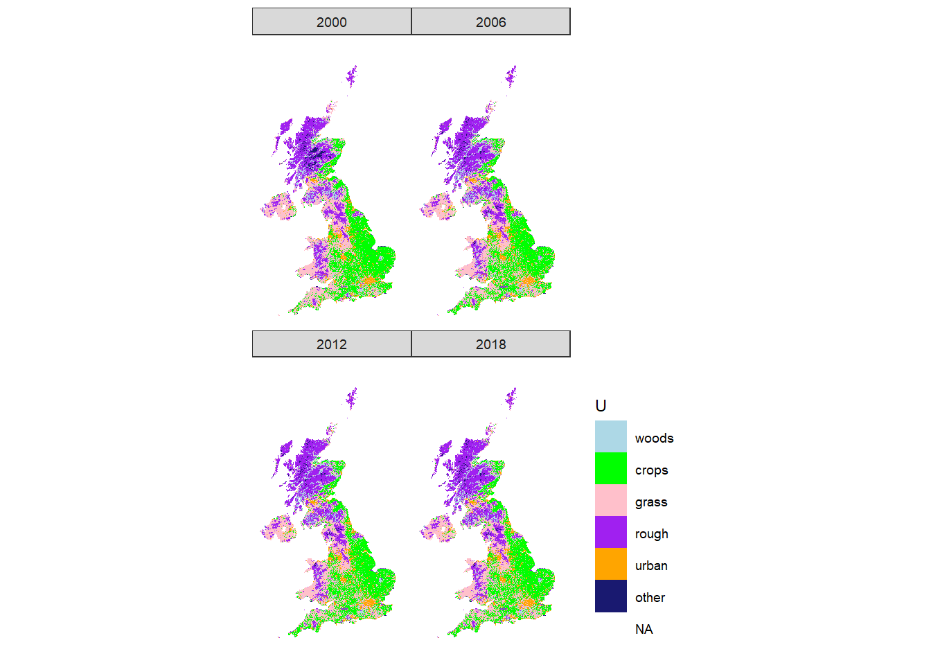
Figure 13.1: Spatial distribution of LULUCF land-use classes in the UK according to CORINE.
References
“CORINE Land Cover — Copernicus Land Monitoring Service.” n.d. Land Section. Accessed November 13, 2020. https://land.copernicus.eu/pan-european/corine-land-cover.